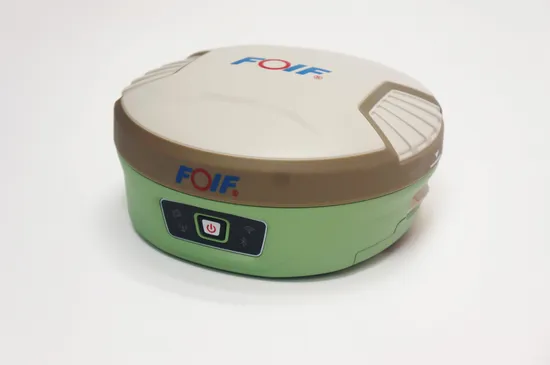
Topographic Surveying Instrument Foif A90 High Precision Gnss Rtk Receiver
Basic Info.
Model NO.
FOIF A90
Type
Geodesic Receiver
Accuracy
1mm
Vertical Lines
1
Horizontal Line
1
After-Sales Service
Warranty, Training
Warranty
1 Year
Initialization Time
<10s
Initialization Reliability
>99.99
Water-Proof & Dust-Proof
IP68
Drop Resistance
2 Meters at Normal Temperature
Humidity
Anti-Condensation
Transport Package
Carton
Specification
35*20*35 cm
Trademark
FOIF
Origin
Guangzhou, China
HS Code
8526919090
Production Capacity
10000
Packaging & Delivery
Package Size
35.00cm * 20.00cm * 35.00cm
Package Gross Weight
6.000kg
Product Description
Product Description
1) Smart Design
With the increasing demand for smart-design GNSS, to develop the receiver featured with miniaturization turns into our new goal until today it comes true. It is completely no doubt that small size and light weight design can greatly alleviate general field work and improve productivity a lot.
2) Brand new idea
In terms of cellular mobile and wireless system, we tend to introduce more and more creativities into our product. Besides a set of bluetooth, wireless radio and mobile network, we bring in the WIFI function which quite broaden data communications for GNSS.
3) Excellent performance
Embedded with high-sensitivity GNSS module , A90 can implement massive surveys:
RTK, DGPS, (SBAS) , Static, etc.
Product Parameters
| Type | A90 | ||||
| GNSS System | 1408 channels | ||||
| Performance | Static measurement plane accuracy | ±(2.5mm + 0.5ppm)RMS | |||
| Static measurement elevation accuracy | ±(5mm + 0.5ppm)RMS | ||||
| RTK measurement plane accuracy | ±(8mm + 0.5ppm)RMS | ||||
| RTK measurement elevation accuracy | ±(15mm + 0.5ppm)RMS | ||||
| SBAS postion(typical) | 0.5m | ||||
| Initialization time | <10s | ||||
| Initialization reliability | >99.99 | ||||
| Environment | Working temperature | -30ºC~ +60ºC | |||
| Storage temperature | -40ºC~ +80ºC | ||||
| Water-proof & Dust-proof | IP68 | ||||
| Drop resistance | 2 meters at normal temperature | ||||
| Humidity | Anti-condensation | ||||
| Storage/data | Built-in storage | Onboard 8G, Support TF card expansion≥32G | |||
| Differential output | RTCM2.3, RTCM3.X, RTCM3.2, CMR, CMR+,RTCA | ||||
| Data safety | Data will be stored and backed up in three places after surveying | ||||
| Satellite Antenna | High performance 4 in 1 antenna: GNSS antenna/Bluetooth/WIFI/4G full netcom module is highly integrated | ||||
| Wireless communication | Bluetooth | Built-in V2.0 Class2 | |||
| WIFI | Directly connected to the handheld controller via wifi instead of bluetooth, support web UI wireless management: device upgrade, data download, parameter setting, station operation, etc. | ||||
| Communication protocol | PCC-EOT, TrimTalk 450S, TrimMark III,South,GeoTalk,GeoMark,Satel,HI-TARGET,ect. | ||||
| UHF radio | Bulit-in transceive | 0.5/2W | Effective distance≥5km | ||
| External transmit | 2/35W | Effective distance≥15km | |||
| Working Frequency | 410-470MHz | ||||
| Physical and Power Characteristics | Size | Φ15.6cm×7.6cm | |||
| Material | Lower cover is magnesium alloy, Top cover is polymer plastic | ||||
| Battery volume | 7.4V×3700mAH×2, Intelligent lithium battery, self power display | ||||
| User interface | 4 LED indicators, 1 button,voice | ||||
| Working time | >8 hours | ||||
| Auxiliary function | Electronic bubble, 2nd generation tilt survey function | ||||
Certifications
Factory Photos
Our Productions
>> Asiapo China Factory Men′s Cover Knees Expedition Fashion Stylish Parka Thicken Warm Comfortable Down Coat Long Waterproof Quilted Padded Puffer Jackets
>> Two-Component Silicone Coating Machine Double Glass Production Line
>> 4lz-6.0p 102HP World Used Combine Harvester
>> Hot sale woven wire mesh aluminium copper coffee air teapot filter mesh
>> Apu08EL UTV/ATV/Chinese Made All-Terrain Vehicle with Tractor Farmer′ S Truck
>> yellow g10 sheet epoxy resin sheet green fiberglass sheet fr4 plate
>> Brand New 1:1 High Quality Watch Men's Fashion Luxury 904L Stainless Steel Sapphire Glass Waterproof Watch
>> 2.5L PP PE Bottles Automatic Blow Molding Machine
>> Kiosk Receipts Line Thermal Printing A4 Thermal Printer
>> Decorative Glass Coloured Jade Glass for Home Decoration
>> Freeze Dried Black Currant, Fd Black Currant Whole From China
>> Disposable Eco-friendly Natural Bamboo Straws Biodegradable Bamboo Straws Bulk For Drinking
>> Automobile Engine Flywheel Grinding Machine Fg500
>> Auto wheel trim 84850237 FOR BUICK ENVISION S 2020-2021
>> Extruded White/Black/Blue preservative Nylon 6 PA6 Sheet
>> Golden Foil Tile Stickers Decoration Tape Wall
>> Disposable Medical Use PE Apron Without Sleeves Kitchen Use Colorful Waterproof Plastic Apron
>> Primapress We67K 250t/6000 Press Brake Machine Steel Bending Machine
>> Plastic PE PP Pet Pulverizing and Grinding Machine
>> Industrial Waste Wood Pallet OTR Tire Car Tyre Plastic Scrap Metal Shredder with Good Price
>> Multifunction Portable High Temperature Industrial Dehumidifier From China Manufacture
>> Pellet Die Chamfering Machine
>> RP-SMA Male to RP-SMA Female RG316 Wire, SMA RG316 Adapter Cable
>> Hot sale auto lighting assembly LED DRL low version headlamp headlight plug and play for TOYOTA camry head lamp head light 2018
>> Bulldozer Hydraulic Winch for Lift Pipe
>> Wholesale Fitness Commercial Treadmill 1.5HP Fitness Running Machine
>> New Design CE Approved 5 Inches Tractor Pto Hydraulic Chipper Shredder
>> Threaded Aluminium Conduit Body Lr Type Outlet Box Caja Salida Conduleta
>> Sportrak Economy PCR Winter Car Tyre UHP/Van/SUV/4X4/at/Mt Tyre 175/70/13 175/65/14 205/70/15 195/50/16 195/65/15 205/55/16 New China Passenger Car Tires
>> Domestic Ga Small Case Aluminum Gas Meter